SO...now after all this time, I went back and looked...and one blog post was missing. I had written this all up the day it happened and somehow the blog website never posted it. This was one of my favorite adventures, too...so now I'll repost it. This occurred during our Valdez trip on the day before we took the ferry...
***
***
After I finished writing the previous post upon our arrival in Valdez, Matt and I went out to explore the town and to get dinner. This gave us a better look at what was around this city.
Valdez seemed, to me, to be exactly like the other Alaskan port cities of Homer or Seward, only with much less charm and far more industry. Its touristy downtown consisted of this one street along the waterfront.
 Most of the businesses there are either small restaurants, glacier/sightseeing cruise companies, or fishing tours. Even so, there are only about a dozen or so businesses there. Valdez has what looks to me like a smaller harbor than Homer or Seward, though it was still decently sized. Most of the industrial ship-loading equipment is located on the other side of the bay with the Alyeska Pipeline terminal. There weren't many touristy gift shops or anyhing like that, so I didn't find a place to buy postcards or anything. We then drove out to the "Original" Valdez Townsite. Valdez was one of the places hardest hit by the giant waves generated from the 1964 Good Friday Earthquake in Alaska. The waves apparently rose up and completely swamped and destroyed downtown Valdez. So, they moved the town to a place four miles down the bay. I'm not sure that puts them in any better position if another giant wave were to come but...they moved the town. What's left of the old townsite are a bunch of random gravel roads with remnants of sidewalks and wooden walkways still visible, all running in a miniature grid throughout this grassy marsh at the end of the bay.

In the water by where the old port of Valdez used to be, you can see the pilings that used to support the main pier in town, as well as some old, rusted machinery that was left behind. I'm amazed that they've let all of this just sit here since 1964...it's still in recent enough memory that a lot of local residents were alive and remember well what happened that day. However, the entire subject and its remnants are treated with a museum-like atmosphere that makes it feel like this disaster happened centuries ago. It's an interesting atmosphere surrounding that earthquake.
 The next day, Matt and I set out for our destination (chosen by me) of the city of McCarthy, Alaska, and the Kennecott Mines nearby. There are only two ways to get to McCarthy--you can either fly in or drive down the Edgerton Highway and McCarthy Road--the latter half of which is an unpaved, gravel, 1-lane drive for 50 miles on an old railroad bed into McCarthy. According to my Milepost guidebook, this route was recommended for those who like "adventurous drives." We would find out.
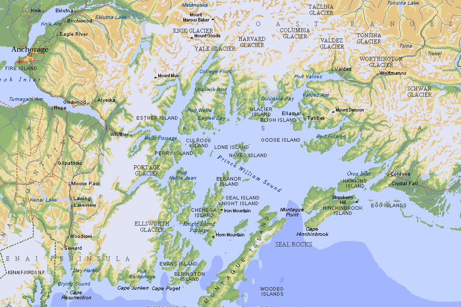
However, the route to McCarthy begins as the Edgerton Highway, which branches off the Richardson Highway some 85 miles north of Valdez. The Edgerton Highway heads into the heart of the Copper River Valley region of Alaska, which is a rather broad, flat region that runs all the way to the Wrangell Mountains in the east. On a clear, non-hazy day, the skyline in the above photo would be dominated by the great stratovolcanoes of the Wrangell Mountains, but today there was a fire to the south that was spreading smoke up north. This haziness really hampered our views of what should have been a spectacular mountain setting. Nevertheless, it was a pleasant, scenic drive.
 Thirty-three miles down the Edgerton Highway, we came to the town of Chitina (which is pronounced like Chit-na...the second i is apparently silent). This is the last stop with gas and food services on the route before you begin the McCarthy Road. It's also the place where the pavement ends. Chitina sits in a very scenic little valley at the junction of the Copper River and the Chitina River. The Edgerton Highway and McCarthy Road follow what used to be old railroad beds, in particular for the Copper River and North-Western Railroad which was built solely to transport copper ore from the mines at Kennecott out to the port of Cordova on the coast. You may remember several posts back when I was flying to Juneau my plane stopped in Cordova. I talked about how there was a highway, the Copper River highway, that ran out northeast of town for a ways before randomly ending in the middle of nowhere after going over a "Million-Dollar Bridge" over the Copper River. That highway in Cordova follows the southern end of the old Copper River and North-Western Railway bed. There are miles of abandoned railroad grade between the end of the Copper River Highway outside of Cordova and here in Chitina, where the road once again picks up on the old railroad bed. Eventually the state of Alaska has plans to connect the two, but that could be a long ways off. Anyhow, when the railroad was active, Chitina was a major stopping point for it, about halfway between the mines at Kennecott and Cordova on the coast. There were thousands of people living in the town in the early 1900s and it used to be one of the largest cities in the state. The photo above shows all that's left of it. It's not much.
 Then the Edgerton Highway ends and the McCarthy Raod begins. You can see here that the pavement ends and the road narrows considerably to travel the remaining 60 miles in to McCarthy.
 Immediately upon leaving Chitina, the road crosses the Copper River itself, and it is quite the mighty river--worthy of all of the things named after it. This area of the Copper River is popular for dipnet fishing. This basically involves taking huge nets on the ends of long poles and running them through the water when the salmon are running, virtually guaranteeing a catch of fish. It is a method used by many natives and rural Alaskans for obtaining food for subsistence and, because it is so "simple," the state of Alaska limits dipnet fishing to only current citizens of the state. This means that none of us out-of-state people can participate in it.
 The McCarthy Road has many scenic moments. Because the road is all gravel, it's extra challenging to drive and requires a lot of concentration. Many times you'll come around a curve and there will be a car coming the other way. The road has several winding spots where the road is very rough and full of washboard sections that force you to slow to almost a crawl. I lost half of the coins out of my little change bin in my car on the drive out, simply from all the bouncing around in the car. However, there are also several long, straight sections where the gravel has been totally packed down and its practically as smooth as pavement.
 On these sections, you can get your speed up to 55 mph for a while with no trouble. Otherwise, I usually averaged around 35-40 mph going down the road. This means it took about one and a half hours to reach McCarthy--all down this gravel road.
 The road doesn't actually go into McCarthy. It stops at several small parking areas at the edge of the rushing Kennicott River where you leave your car. Some parking areas are free, others require you to pay for the day. We chose one a little further out that was free. From there, it was about a half-mile walk down the road to a footbridge over the Kennicott River (the river is spelled Kennicott with an 'i' and the mining town is spelled Kennecott with an 'e'...apparently it was a very old clerical error...).
 On the far side of the footbridge you can see a van waiting. Every half hour or so, the Wrangell Mountain Air Tours people have shuttle vans that run between the end of the footbridge, the town of McCarthy and the Kennecott mines. The actual town of McCarthy is about 3/4 of a mile from the end of the footbridge, and the Kennecot mines are another 4.5 miles beyond that. Matt and I figured we could walk into McCarthy, but would probably have to take the shuttle out to Kennecott. The shuttle costs $5 for one way and $10 for round trip. That $5 one way gets you from any point on the run to any other point on the run.
 The view to the north from the footbridge was stunning. Up on the mountainside was the massive Root Glacier. At the base of the glacier was this extensive field of glacial moraine hills that looked like piles and piles of dirt, gravel and sand all spread around like sand dunes. Such an amazing vista. Note how clear it was at this point.
Matt and I then walked the easy 3/4 mile into McCarthy. I knew that McCarthy was supposed to be a very small town, retaining much of its appearance from its mining days in the early 1900s. This is the view upon turning down Main Street in downtown McCarthy.
 And this is what downtown McCarthy actually looks like.
 The town of McCarthy started as a service location for the miners and other workers up at the Kennecott Mines. Though all the workers lived on site at the mining town up in Kennecott, the mine owners placed the usual restrictions to make it a proper company town--no alcohol, no cigarettes, no vice of any kind. In response, the town of McCarthy sprang up about 5 miles south and off of the mine's property, featuring several saloons, brothels, and various other stores that stocked goods that were not sold in the Kennecott company store. When the mines closed in the late 1930s, the town of McCarthy basically shut down as well. It is currently enjoying a decent revival, though, as tourism to the Kennecott mines has exploded in the last few years. The town is currently home to some 50 permanent residents, who live in homes scattered throughout the area down random gravel roads. There is a general mercantile store in downtown McCarthy that stocks groceries and other goods, two restaurants that I saw, a small clothing store, and several tour companies. All the mountains you see in the backgrounds of these photos are peaks in the Wrangell Mountains, though none are the massive volcanoes the range is known for. The McCarthy-Kennecott area is located in the heart of Wrangell-Saint Elias National Park, and McCarthy is fast becoming a major launching point for backpackers and other adventurers who are exploring the park. With these adventurers and renewed interest in visiting the mines, McCarthy is starting to boom once again. Literally, that's all there is to the town now, though...
Matt and I bought something to drink at the mercantile and then got tickets from the Wrangell Mountain Air place to take the shuttle up to Kennecott. We also signed up for the 3:30 PM tour of Kennecott for $25. If you go back two photos to the one with the big glacier, the Kennecott Mining town is located at the base of the mountains to the right, above the big field of glacial till and moraines. Here's a closer view of what that area looks like through the trees as we drove by it. Such a bizarre landscape...almost looks completely unnatural and out of place.
 We then arrived up at the main road in Kennecott, through the mining town. The tour launched from this point. The National Park Service bought the Kennecott mining town in the 1990s and major renovation and refurbishment work on all the buildings is currently ongoing. Thus, many parts of this "abandoned" mining town are extraordinarily neat and restored. It actually is a very pleasant-looking place.
 If you imagine taking that photo above and turning left 90 degrees, this is what you see---that eerie dune-filled landscape again.
 What's more incredible, though, is the fact that you can see this wall of smoke and ash moving up the valley from the south. The winds had just shifted, and the smoke from the major wildfire to the south was moving northward en-masse. I've never seen smoke have such a pronounced edge like that before...
 Our tour was rather long--two and a half hours--but very, very informative and entertaining. We walked past several of the buildings. There you see the Kennecott Lodge up on the hill. Since the previous owners of the mine sold various parts of it to private individuals, the park service doesn't own every building. This lodge is an example of one of the privately owned buildings. Completely renovated and refurbished, the lodge is now a 35-room hotel with a full restaurant. Apparently it's very hard to get reservations to stay there, since it is always booked up. I was surprised at how many people were out in the mining town...we ran into maybe a dozen or so people in McCarthy, but up at the mines I saw at least 50...maybe more. Don't know where they all came from...
 You can see here how the park service is refurbishing this place. The building in the foreground used to be a bunkhouse for mine workers. It's currently in the process of being redone by the park service, but you can still see the worn out paint and all the broken windows. In the background is the main storage building for the mining town, and that building has been refurbished...note the deck has a nice red railing and all the trim is painted and the roof redone. Almost every building a Kennecott is painted red for the same reason that all those turn-of-the-century schoolhouses were painted red--it was the cheapest color of paint available at the time. I really enjoy the image of the red and white buildings at this place.
 The world's richest and densest concentration of copper ore was discovered in the mountains above Kennecott by prospectors in 1900. Instead of me going into the full history of the mines here, I invite you to read the Wikipedia article on the mines at http://en.wikipedia.org/wiki/Kennecott,_Alaska. It will just save me a lot of space here. Anyhow, obviously one of the first things you need to have when you want to build a mine is a sawmill so that you can cut the lumber needed to build all the rest of the mining buildings. The photo above is what remains of the sawmill, oddly one of the only buildings in the entire mining complex to completely collapse--most remain quite intact. Since they didn't have a sawmill to begin with, the sawmill itself was made out of very poorly hewn and assembled timbers, thus it didn't stand up to the test of time.

Valdez seemed, to me, to be exactly like the other Alaskan port cities of Homer or Seward, only with much less charm and far more industry. Its touristy downtown consisted of this one street along the waterfront.
Most of the businesses there are either small restaurants, glacier/sightseeing cruise companies, or fishing tours. Even so, there are only about a dozen or so businesses there. Valdez has what looks to me like a smaller harbor than Homer or Seward, though it was still decently sized. Most of the industrial ship-loading equipment is located on the other side of the bay with the Alyeska Pipeline terminal. There weren't many touristy gift shops or anyhing like that, so I didn't find a place to buy postcards or anything. We then drove out to the "Original" Valdez Townsite. Valdez was one of the places hardest hit by the giant waves generated from the 1964 Good Friday Earthquake in Alaska. The waves apparently rose up and completely swamped and destroyed downtown Valdez. So, they moved the town to a place four miles down the bay. I'm not sure that puts them in any better position if another giant wave were to come but...they moved the town. What's left of the old townsite are a bunch of random gravel roads with remnants of sidewalks and wooden walkways still visible, all running in a miniature grid throughout this grassy marsh at the end of the bay.In the water by where the old port of Valdez used to be, you can see the pilings that used to support the main pier in town, as well as some old, rusted machinery that was left behind. I'm amazed that they've let all of this just sit here since 1964...it's still in recent enough memory that a lot of local residents were alive and remember well what happened that day. However, the entire subject and its remnants are treated with a museum-like atmosphere that makes it feel like this disaster happened centuries ago. It's an interesting atmosphere surrounding that earthquake.
The next day, Matt and I set out for our destination (chosen by me) of the city of McCarthy, Alaska, and the Kennecott Mines nearby. There are only two ways to get to McCarthy--you can either fly in or drive down the Edgerton Highway and McCarthy Road--the latter half of which is an unpaved, gravel, 1-lane drive for 50 miles on an old railroad bed into McCarthy. According to my Milepost guidebook, this route was recommended for those who like "adventurous drives." We would find out.However, the route to McCarthy begins as the Edgerton Highway, which branches off the Richardson Highway some 85 miles north of Valdez. The Edgerton Highway heads into the heart of the Copper River Valley region of Alaska, which is a rather broad, flat region that runs all the way to the Wrangell Mountains in the east. On a clear, non-hazy day, the skyline in the above photo would be dominated by the great stratovolcanoes of the Wrangell Mountains, but today there was a fire to the south that was spreading smoke up north. This haziness really hampered our views of what should have been a spectacular mountain setting. Nevertheless, it was a pleasant, scenic drive.
Thirty-three miles down the Edgerton Highway, we came to the town of Chitina (which is pronounced like Chit-na...the second i is apparently silent). This is the last stop with gas and food services on the route before you begin the McCarthy Road. It's also the place where the pavement ends. Chitina sits in a very scenic little valley at the junction of the Copper River and the Chitina River. The Edgerton Highway and McCarthy Road follow what used to be old railroad beds, in particular for the Copper River and North-Western Railroad which was built solely to transport copper ore from the mines at Kennecott out to the port of Cordova on the coast. You may remember several posts back when I was flying to Juneau my plane stopped in Cordova. I talked about how there was a highway, the Copper River highway, that ran out northeast of town for a ways before randomly ending in the middle of nowhere after going over a "Million-Dollar Bridge" over the Copper River. That highway in Cordova follows the southern end of the old Copper River and North-Western Railway bed. There are miles of abandoned railroad grade between the end of the Copper River Highway outside of Cordova and here in Chitina, where the road once again picks up on the old railroad bed. Eventually the state of Alaska has plans to connect the two, but that could be a long ways off. Anyhow, when the railroad was active, Chitina was a major stopping point for it, about halfway between the mines at Kennecott and Cordova on the coast. There were thousands of people living in the town in the early 1900s and it used to be one of the largest cities in the state. The photo above shows all that's left of it. It's not much.Then the Edgerton Highway ends and the McCarthy Raod begins. You can see here that the pavement ends and the road narrows considerably to travel the remaining 60 miles in to McCarthy.Immediately upon leaving Chitina, the road crosses the Copper River itself, and it is quite the mighty river--worthy of all of the things named after it. This area of the Copper River is popular for dipnet fishing. This basically involves taking huge nets on the ends of long poles and running them through the water when the salmon are running, virtually guaranteeing a catch of fish. It is a method used by many natives and rural Alaskans for obtaining food for subsistence and, because it is so "simple," the state of Alaska limits dipnet fishing to only current citizens of the state. This means that none of us out-of-state people can participate in it.The McCarthy Road has many scenic moments. Because the road is all gravel, it's extra challenging to drive and requires a lot of concentration. Many times you'll come around a curve and there will be a car coming the other way. The road has several winding spots where the road is very rough and full of washboard sections that force you to slow to almost a crawl. I lost half of the coins out of my little change bin in my car on the drive out, simply from all the bouncing around in the car. However, there are also several long, straight sections where the gravel has been totally packed down and its practically as smooth as pavement.On these sections, you can get your speed up to 55 mph for a while with no trouble. Otherwise, I usually averaged around 35-40 mph going down the road. This means it took about one and a half hours to reach McCarthy--all down this gravel road.The road doesn't actually go into McCarthy. It stops at several small parking areas at the edge of the rushing Kennicott River where you leave your car. Some parking areas are free, others require you to pay for the day. We chose one a little further out that was free. From there, it was about a half-mile walk down the road to a footbridge over the Kennicott River (the river is spelled Kennicott with an 'i' and the mining town is spelled Kennecott with an 'e'...apparently it was a very old clerical error...).On the far side of the footbridge you can see a van waiting. Every half hour or so, the Wrangell Mountain Air Tours people have shuttle vans that run between the end of the footbridge, the town of McCarthy and the Kennecott mines. The actual town of McCarthy is about 3/4 of a mile from the end of the footbridge, and the Kennecot mines are another 4.5 miles beyond that. Matt and I figured we could walk into McCarthy, but would probably have to take the shuttle out to Kennecott. The shuttle costs $5 for one way and $10 for round trip. That $5 one way gets you from any point on the run to any other point on the run.The view to the north from the footbridge was stunning. Up on the mountainside was the massive Root Glacier. At the base of the glacier was this extensive field of glacial moraine hills that looked like piles and piles of dirt, gravel and sand all spread around like sand dunes. Such an amazing vista. Note how clear it was at this point.Matt and I then walked the easy 3/4 mile into McCarthy. I knew that McCarthy was supposed to be a very small town, retaining much of its appearance from its mining days in the early 1900s. This is the view upon turning down Main Street in downtown McCarthy.
And this is what downtown McCarthy actually looks like.The town of McCarthy started as a service location for the miners and other workers up at the Kennecott Mines. Though all the workers lived on site at the mining town up in Kennecott, the mine owners placed the usual restrictions to make it a proper company town--no alcohol, no cigarettes, no vice of any kind. In response, the town of McCarthy sprang up about 5 miles south and off of the mine's property, featuring several saloons, brothels, and various other stores that stocked goods that were not sold in the Kennecott company store. When the mines closed in the late 1930s, the town of McCarthy basically shut down as well. It is currently enjoying a decent revival, though, as tourism to the Kennecott mines has exploded in the last few years. The town is currently home to some 50 permanent residents, who live in homes scattered throughout the area down random gravel roads. There is a general mercantile store in downtown McCarthy that stocks groceries and other goods, two restaurants that I saw, a small clothing store, and several tour companies. All the mountains you see in the backgrounds of these photos are peaks in the Wrangell Mountains, though none are the massive volcanoes the range is known for. The McCarthy-Kennecott area is located in the heart of Wrangell-Saint Elias National Park, and McCarthy is fast becoming a major launching point for backpackers and other adventurers who are exploring the park. With these adventurers and renewed interest in visiting the mines, McCarthy is starting to boom once again. Literally, that's all there is to the town now, though...Matt and I bought something to drink at the mercantile and then got tickets from the Wrangell Mountain Air place to take the shuttle up to Kennecott. We also signed up for the 3:30 PM tour of Kennecott for $25. If you go back two photos to the one with the big glacier, the Kennecott Mining town is located at the base of the mountains to the right, above the big field of glacial till and moraines. Here's a closer view of what that area looks like through the trees as we drove by it. Such a bizarre landscape...almost looks completely unnatural and out of place.
We then arrived up at the main road in Kennecott, through the mining town. The tour launched from this point. The National Park Service bought the Kennecott mining town in the 1990s and major renovation and refurbishment work on all the buildings is currently ongoing. Thus, many parts of this "abandoned" mining town are extraordinarily neat and restored. It actually is a very pleasant-looking place.If you imagine taking that photo above and turning left 90 degrees, this is what you see---that eerie dune-filled landscape again.What's more incredible, though, is the fact that you can see this wall of smoke and ash moving up the valley from the south. The winds had just shifted, and the smoke from the major wildfire to the south was moving northward en-masse. I've never seen smoke have such a pronounced edge like that before...Our tour was rather long--two and a half hours--but very, very informative and entertaining. We walked past several of the buildings. There you see the Kennecott Lodge up on the hill. Since the previous owners of the mine sold various parts of it to private individuals, the park service doesn't own every building. This lodge is an example of one of the privately owned buildings. Completely renovated and refurbished, the lodge is now a 35-room hotel with a full restaurant. Apparently it's very hard to get reservations to stay there, since it is always booked up. I was surprised at how many people were out in the mining town...we ran into maybe a dozen or so people in McCarthy, but up at the mines I saw at least 50...maybe more. Don't know where they all came from...You can see here how the park service is refurbishing this place. The building in the foreground used to be a bunkhouse for mine workers. It's currently in the process of being redone by the park service, but you can still see the worn out paint and all the broken windows. In the background is the main storage building for the mining town, and that building has been refurbished...note the deck has a nice red railing and all the trim is painted and the roof redone. Almost every building a Kennecott is painted red for the same reason that all those turn-of-the-century schoolhouses were painted red--it was the cheapest color of paint available at the time. I really enjoy the image of the red and white buildings at this place.The world's richest and densest concentration of copper ore was discovered in the mountains above Kennecott by prospectors in 1900. Instead of me going into the full history of the mines here, I invite you to read the Wikipedia article on the mines at http://en.wikipedia.org/wiki/Kennecott,_Alaska. It will just save me a lot of space here. Anyhow, obviously one of the first things you need to have when you want to build a mine is a sawmill so that you can cut the lumber needed to build all the rest of the mining buildings. The photo above is what remains of the sawmill, oddly one of the only buildings in the entire mining complex to completely collapse--most remain quite intact. Since they didn't have a sawmill to begin with, the sawmill itself was made out of very poorly hewn and assembled timbers, thus it didn't stand up to the test of time.This creek runs through part of the mining town. It had a major flood in 2006 with the stream reaching heights that hadn't been observed since the original building of the town. All the buildings seen in this picture had part of their foundations washed away due to the flooding, and that's what's now causing them to collapse. The Park Service is doing whaever they can to stabalize and secure these buildings but some, like the Assayer's office in the front left foreground of the photo, have been so damaged or washed away that they'll likely just be allowed to collapse. The white building in the photo was the hospital for the town, and some mine administrative offices and housing were located in the partially collpsed white house behind that. The buildings on the right were more bunkhouses for the men.
 This is the biggest and most famous building in the town...the massive mill. The primary reason I wanted to take the tour we took was because this tour let you go inside the mill. In doing all my research these past months about things to do in Alaska, I was always haunted by images of that mill building whenever they came up. The Park Service didn't even want to touch it to try and refurbish or restore it, so all they did was secure and stabilize it so it wouldn't collapse. They ASSURED us that it was safe and stable. I still think that building is just amazing looking. In the foreground, you can see a backhoe and some new construction--that's a replacement bridge that goes over the creek seen in he previous photo. The 2006 flood washed out the old railroad trestle that used to be there. You can see how the railroad cars would have crossed there and pulled into the buildings at the base of the mill. Ore from the mines was brought into the mill at the top and they let gravity move the ore down through the various stages of milling--this is why the mill building is so tall and built into the hillside.
 Our tour went to the top of the hill where the ore would have come in and we began our decent through the mill building there. The actual mines themselves are way up in the mountains above the mill and, though there are trails up to them and many people do visit them, there was no time for us to do that on this trip. So we started into the mill building. That did not look like the most inviting place to enter...
 Apparently when the mine was abandoned in he 1930s, they tore the roof off of the upper part of the mill. And some walls too. It seriously looks like a tornado came through and did all this damage...complete with the snapped power-line pole thing in the foreground. The Park Service people assured us this was safe...keep in mind were atop a 22-ish story wooden tower built nearly 100 years ago...
 Even though it REALLY doesn't look safe... there was a "walkway" with handrails on it that we were told to follow. No one even thought about straying from it...
 This is an aerial view of some of the other mine buildings from the top of the mill. You can see the construction progress on that new bridge.
 Looking out the other side, you can see a variety of other plants, including the one with the smokestacks which was the electric power generating building for the mine. You can just see the furthest tendrils of the Root Glacier out in the glacial moraine field out there, but...that smoke had really set in and that's what our visibility was cut down to.
 Anyhow, back inside the mill, our tour group of 14 people carefully poked our way around in there. Such chaos...there are no full floors...there are half floors and drops in the floor and there are sometimes ceilings 6 inches from your head and sometimes ceilings 20 feet above your head. Timbers crossing every which way in no clear pattern...random abandoned machinery just lying around idle. Complete chaos in there...
 Just more chaos. Some of these ladders were unstable and we were told not to use them. This was one place where everyone obeyed the guide to the letter.
 There was a set of red stairs outside of the building that followed a chute leading all the way from the top of the mill to the train tracks below. We were told this was for the highest grade of copper ore that needed no milling...they just put it in the chute straight down to the trains. Otherwise, ore that was less pure had to be crushed and ground up and then separated into copper and non-copper bits or "tailings". That's what a majority of the equipment in the mill was for. Anyhow--that ladder. It's known as the "John Denver" stairs, apparently, because, according to our guide, in one of his songs he mentions the Kennecott mines and McCarthy and in an "Alaskan Special" video, John Devner performed while sitting on these steps. For that reason, the McCarthy-Kennecott area now has an annual "John Denver Tribute Festival" where they gather to play John Denver songs and have a potluck and all that. Being a John Denver fan myself, this intrigued me...
 Anyhow, it took us a full hour to descend through that building. It was so dark and creepy in there...and so completely confusing. Stairways were steep and narrow, everywhere there were broken floorboards and random equipment just laying around. We were told that one summer a bear had found its way into the building and a tour group ran into him about halfway down through the mill. Both the bear and the tour group were scared out of their wits and took off in opposite directions. The tour group scrambled down to the next level, only to walk around a corner and find...that the bear had scrambled down as well! So both the bear and the group were frightened again and took off in opposite directions...such a cartoonish thing. But, we saw no bears and made it out of the building in time to catch the 6 PM shuttle back to the footbridge. I am so glad we took that tour (even if it was a bit scary) and it is definitely a highlight of my Alaskan adventures.
 We then drove another two hours back into Valdez where we quickly fell asleep. But, we had to get up early for the ferry the next day. More on that tomorrow...
This is the biggest and most famous building in the town...the massive mill. The primary reason I wanted to take the tour we took was because this tour let you go inside the mill. In doing all my research these past months about things to do in Alaska, I was always haunted by images of that mill building whenever they came up. The Park Service didn't even want to touch it to try and refurbish or restore it, so all they did was secure and stabilize it so it wouldn't collapse. They ASSURED us that it was safe and stable. I still think that building is just amazing looking. In the foreground, you can see a backhoe and some new construction--that's a replacement bridge that goes over the creek seen in he previous photo. The 2006 flood washed out the old railroad trestle that used to be there. You can see how the railroad cars would have crossed there and pulled into the buildings at the base of the mill. Ore from the mines was brought into the mill at the top and they let gravity move the ore down through the various stages of milling--this is why the mill building is so tall and built into the hillside.Our tour went to the top of the hill where the ore would have come in and we began our decent through the mill building there. The actual mines themselves are way up in the mountains above the mill and, though there are trails up to them and many people do visit them, there was no time for us to do that on this trip. So we started into the mill building. That did not look like the most inviting place to enter...Apparently when the mine was abandoned in he 1930s, they tore the roof off of the upper part of the mill. And some walls too. It seriously looks like a tornado came through and did all this damage...complete with the snapped power-line pole thing in the foreground. The Park Service people assured us this was safe...keep in mind were atop a 22-ish story wooden tower built nearly 100 years ago...Even though it REALLY doesn't look safe... there was a "walkway" with handrails on it that we were told to follow. No one even thought about straying from it...This is an aerial view of some of the other mine buildings from the top of the mill. You can see the construction progress on that new bridge.Looking out the other side, you can see a variety of other plants, including the one with the smokestacks which was the electric power generating building for the mine. You can just see the furthest tendrils of the Root Glacier out in the glacial moraine field out there, but...that smoke had really set in and that's what our visibility was cut down to.Anyhow, back inside the mill, our tour group of 14 people carefully poked our way around in there. Such chaos...there are no full floors...there are half floors and drops in the floor and there are sometimes ceilings 6 inches from your head and sometimes ceilings 20 feet above your head. Timbers crossing every which way in no clear pattern...random abandoned machinery just lying around idle. Complete chaos in there...Just more chaos. Some of these ladders were unstable and we were told not to use them. This was one place where everyone obeyed the guide to the letter.There was a set of red stairs outside of the building that followed a chute leading all the way from the top of the mill to the train tracks below. We were told this was for the highest grade of copper ore that needed no milling...they just put it in the chute straight down to the trains. Otherwise, ore that was less pure had to be crushed and ground up and then separated into copper and non-copper bits or "tailings". That's what a majority of the equipment in the mill was for. Anyhow--that ladder. It's known as the "John Denver" stairs, apparently, because, according to our guide, in one of his songs he mentions the Kennecott mines and McCarthy and in an "Alaskan Special" video, John Devner performed while sitting on these steps. For that reason, the McCarthy-Kennecott area now has an annual "John Denver Tribute Festival" where they gather to play John Denver songs and have a potluck and all that. Being a John Denver fan myself, this intrigued me...Anyhow, it took us a full hour to descend through that building. It was so dark and creepy in there...and so completely confusing. Stairways were steep and narrow, everywhere there were broken floorboards and random equipment just laying around. We were told that one summer a bear had found its way into the building and a tour group ran into him about halfway down through the mill. Both the bear and the tour group were scared out of their wits and took off in opposite directions. The tour group scrambled down to the next level, only to walk around a corner and find...that the bear had scrambled down as well! So both the bear and the group were frightened again and took off in opposite directions...such a cartoonish thing. But, we saw no bears and made it out of the building in time to catch the 6 PM shuttle back to the footbridge. I am so glad we took that tour (even if it was a bit scary) and it is definitely a highlight of my Alaskan adventures.We got back to the footbridge and, now that I knew where all the turns and rough spots were, we made excellent time back down the McCarthy Road into Chitina and pavement. We stopped in Chitina, actually, and ate dinner at the Hotel Chitina--just like Copper Center Roadhouse, another randomly delightful restaurant in a random, middle-of-nowhere place in Alaska.
We then drove another two hours back into Valdez where we quickly fell asleep. But, we had to get up early for the ferry the next day. More on that tomorrow... PS. I can't emphasize enough--keep in mind just how far away from everything all of today's activities were. It took us nearly 4 hours of driving from Valdez to get to McCarthy, and along that entire way we went through only one other town--Chitina. And in Chitina there were hardly any services--one small-store, shady-looking gas station and the restaurant we ate at and that was is. It was a 60 mile long gravel road into McCarthy---there are no other towns or settlements anywhere within that 60 mile radius of the city. And yet, this whole huge mining complex and the town of McCarthy with all of its tourists and adventurers and whatnot...they're all there. It just amazes me. My entire concept of "remote" has been completely changed by trips like this, the Alaska Highway, and driving up through the Brooks Range and the North Slope. Incredible.


