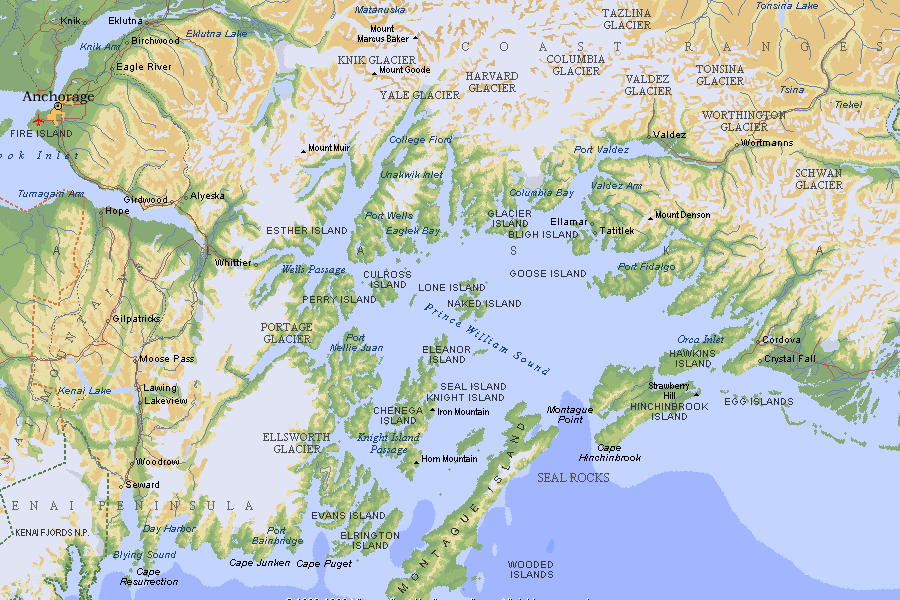
The ferry from Valdez to Whittier is part of the Alaska Marine Highway System. Many of the coastal cities in Alaska have no road connection or lie at the ends of roads, and getting from place to place can require major detours inland. Thus, the Alaska Marine Highway was born. It's an official part of the Alaska State Highway system and is even eligible for federal funding through the interstate highway system because one of its connections is at Bellingham, Washington. The Alaska Marine Highway System (I'm going to use the AMHS acronym from now on) is one of the primary modes of transportation between the many towns on the many islands in southeastern Alaska, places like Juneau, Sitka, Ketchikan and Skagway. However, there is a "cross-gulf" route that goes across from Juneau to ports on Prince William Sound like Valdez and Whittier that are connected to the mainland road system. This greatly simplifies travel to the rest of the state from Juneau, as it affords people with cars a way of getting them out of Juneau and to someplace else.
The ferry also has a western branch to its system, with departures from Homer on the Kenai Peninsula out to Kodiak Island (famous for its bears) and then west along the Alaska Peninsula through the Aleutian Islands to the cities of Unalaska/Dutch Harbour. When I ge the money one day and can come back up here, I would love to take the 3 day--2 night ferry ride out from Homer and Kodiak to Unalaska/Dutch Harbour, slowly cruising by all of those islands in the Aleutian Chain. It's expensive, but not moreso than any other method of travel. The cost to transport a single passenger out to Dutch Harbour is around $800 one way, which is about the cost of a plane ticket to go out there anyhow. I would plan to take the ferry out there and then drive back.
The city of Anchorage does not have immediate access to the AMHS, as they expect you to drive to Whittier or Homer to pick up the ferry. It's meant to be a supplement to the road system instead of an alternative, for the most part. However, we just wanted the experience of riding the ferry, so we went for it.
It cost us $89 per person to get passage across Prince William Sound, and another $105 to transport my car. Rather expensive, but we still wanted the experience. The cost and scheduling are the most prohibiting things to travelling on the AMHS.
Case in point, the only ferry that would allow vehicles on it was the 5 hour and 45 minute ferry that left Valdez at 8 in the morning. There was a second ferry leaving around noon that only took three and a half hours, but this "express" ferry didn't allow vehicles. Twice on my confirmation email and on the AMHS website appeared the line "FOR ALL FERRY PASSENGERS WITH VEHICLES TO/FROM WHITTIER--CHECK IN IS 3 HOURS PRIOR TO SCHEDULED DEPARTURE". This meant we had to check in at the ferry office by 5 AM. Early morning...
 We got up at 4 in the morning and were at the ferry terminal by 5 AM (the terminal was only a five minute drive from our hotel). It was very foggy and rainy in Valdez, but still light out, since it's always light out up here. The lights in the ferry terminal, however, were all dark and a sign in the window said that they were closed. This bothered me. So we parked the car and I went up to read all the signs posted in the window. The largest was a schedule which listed all the departure times and the phrase "All departures must check in one hour prior to departure." One hour. We now had two hours of nothing to do. Very disappointing. So, Matt went back to sleep and I read for an hour and a half until someone showed up and the terminal opened. We went inside and picked up our tickets. We then got back in the car and were directed to a holding area by the ferry. There were already six vehicles there. I don't know how six vehicles got in ahead of us when we were sitting there in front of the terminal the whole time, but somehow they did.
 In the photo above you can see the ferry on the other side of the covered sidewalk. This was in the holding area. We waited there for another half an hour before they finally began boarding the vehicles.
 On board the ferry, we turned to the left which would be toward the aft of the ship. There's a wide deck inside, but we were told by the crew members there that I would have to back down into this narrow side "hallway" of sorts because my car was small enough. I don't like backing vehicles into anything, and everyone else somehow seems to be very good at it, but I'm not. They had people directing me though, and after watching these other drivers get yelled at and crew members running toward them yelling "NO! NO! STOP! STOP!" my nearly flawless parking job meant all the more to me. They packed the cars in very, very tight.
 This is the first time since I've had this car that the car has been able to travel somewhere without having to do all the work in getting it there. I felt good about giving my car this break, particularly after all its been through in the past few months, even more so after driving down the McCarthy Road the day before. You're not allowed to access your vehicles during transit, so Matt and I collected a few things then climbed the stairs to the surprisingly lush passenger deck.
 This was the foreward observation lounge. It reminded me of a theater, but with windows instead of a screen or stage. The chairs were all very plush and they all reclined--wide seats with plenty of legroom too. If only flying could be so comfortable. I enjoyed watching the rest of the vehicles go down the ramp into the ship for a while.
 Somehow they got all the cars in and we shoved off right on time. The fog was very dense and it was pouring rain, so for the first hour or so we didn't see anything at all except white emptiness. The boat moves at around 14 knots, but the waters were also very calm and you could hardly feel that we were moving. A member of the US Forest Service was on our ferry, and the AMHS has Forest Service or National Park employees on many of their ships to act as guides and answer questions to take the pressure off the crew. Our guide set up a schedule where every hour he gave a 15 minute presentation on some aspect of our surroundings--be it glaciers, fishing, fox farming, or the city of Whittier. I found this to be very entertaining and fun. Our guide was an elderly man who lived in North Carolina, but came to Alaska with his wife every summer and the two of them did work for the Forest Service. Apparently there are a lot of people with summer jobs in Alaska...
 After a time, the fog began to clear a little and we could see a bit of the surroundings. The ship's bell is out front and the label on it has our ship's name, the Aurora. I went outside to the outer deck that runs around the outside of the ship and was able to take in the misty scenery.

 After a short while, we passed Bligh Reef, which was the actual location of the Exxon-Valdez oil spill. This is how it looked through the fog--all cleaned up now.
 Soon we passed north of an island called Glacier Island and entered a strait between it and the northern shore of the Sound. Apparently the very large Colombia Glacier was to our north, but we couldn't see it through the fog. However, chunks of ice that had calved off the glacier recently started showing up all around.
 Some of these icebergs came VERY close to the ship. I think everyone has ingrained in them he danger of icebergs to ships because of the whole Titanic thing. A lot of people on board the ship became very edgy as these bergs came in closer. The captain and our Forest Guide had to keep assuring people that everything was all right. I just went outside and took pictures.
 The fog set in again, though, and we spent most of the rest of the trip lost in obscurity. There was a full-service, cafeteria-style galley behind the observation lounge and when they opened at noon for lunch Matt and I ate. I enjoyed a fish (cod) and chips meal that I didn't expect to find on this ride at all...I had no idea they had a cafeteria on these cruise ships. Very pleasant find.
On the way there, I noticed the familiar "Alaska Scenic Byway" sign that I had seen on so many roads in the state. Apparently, since the ferry system is funded as part of the state highway system, they can declare the ferry as a "Scenic Byway". Strangest scenic byway I've ever been on...
 Anyhow, we were due to arrive in Whittier around 1:30, so we soon approached.
 Whittier is a very funny kind of town. It's only a little over an hour from Anchorage by road, down past the end of Turnagain Arm. There's only a small strip of land separating the eastern end of Turnagain Arm from Prince William Sound. Once again, see the map I linked to above for better details. This strip of land is that low ridge of mountains you see behind Whittier. Without that strip of land, the entire Kenai Peninsula would instead be Kenai Island. Of course, as we can see here, Whittier is on the Prince William Sound side of these mountains and not on the Turnagain Arm side. In the 1940s, the US Military established the town of Whittier as a military outpost during World War II. Turnagain Arm and the Cook Inlet (where Anchorage is) freeze over during the winter, but Prince William Sound does not. Thus, the military wanted an ice-free part that was near Anchorage and thus Whittier was born. Of course, accessing Whittier from the Anchorage side was still a problem, so the Army Corps of Engineers constructed a 2.6 mile long tunnel under the mountains to connect Whittier with the rail line to Anchorage. More on that later.
In the photo above you can see two large buildings. The tall, lighter-colored one on the right is called the Begich Towers and 75% of Whittier's population of almost 200 live in that one building. The other 25% live in one of two other condominium/apartment buildings nearby. The other, lower, darker building on the left is called the Buckner Building, and at one time it was the largest building in Alaska. Back in the days when Whittier was a military town, the entire population lived in that one building. However, it was abandoned in the 1960s (before the 1964 earthquake, actually) and today no one knows who owns it. The building, though huge, is completely abandoned and condemned as well. People had planned to tear it down, but the building is full of asbestos, which complicates matters. The city of Whittier once offered to let Steven Spielberg blow it up for one of his movies, but he learned he would have to pay several millions of dollars to then clean it all up--which is difficult not just because of the asbestos, but also because the only way out of Whittier is by boat/barge or through the very narrow tunnel. So the building remains abandoned, but several local residents and many tourists still go into it to explore. I'm told the building smells horrendous, several of the lower floors are flooded, walls are caving in, ceilings are collapsing, and bears hibernate in the building for the winter. But people still go there...
 We departed the ship and drove towards the tunnel out of Whittier. On the way, we passed this building that, on a sunny day, is what I have often thought one of the most picturesque buildings I've seen in Alaska. It's called The Inn at Whittier and is one of the few places with lodging that you can find in this 3-street town. I have wanted to eat at the restaurant for some time now, but I'm told it's very pricy. One day I'll find out. The rest of Whittier is the harbour with all of the small boats and a lot of the little shacks offering fishing, wildlife, and glacier tours. There are no real "shops" or anything else...in fact, there really isn't anything to do in Whittier unless you catch one of those cruises or the ferries there. Other people have insisted to me that there's "tons!" to do in Whittier, but all I can ever get them to remember is that they bought fudge at a shop there. It's a strange town.
We approached the tunnel, which was only upgraded to include car traffic about a decade ago. At 2.6 miles long, it is the longest car-train combined tunnel in the world, and the second longest automobile tunnel now that the Big Dig in Boston is complete. Normally, coming in from the Anchorage side, there is a toll of $12 round trip you have to pay to use the tunnel. There is no toll booth on the side leaving Whittier, so if you're like us and come in on the ferry, you don't have to pay anything, which I greatly enjoyed. Since the tunnel is only one lane wide, it alternates between which direction gets to go at which times. Every hour on the hour for the first 15 minutes of the hour, traffic out of Whittier is allowed to go through the tunnel. Then it shuts down and if there's a train, the train can go through. Then, at thirty past each hour, a 15 minute window opens for traffic going into Whittier from the Anchorage side. Thus, for whatever direction you're going, you really only have 15 minutes every hour when you can get through the tunnel. The tunnel also closes at 11 PM and I don't know when it opens in the morning...so it's conceivable that you can get stuck in Whittier. Anyhow, since we got in at 1:30, we were able to make the window that opened at 2 PM with no problem. First, we waited in a staging area until we were signaled to enter.
 The zoom on my camera was zoomed in a bit much for this photo, but you can see the narrowness of the tunnel. They also send the cars in relatively tightly. It's rather dark in the tunnel, but my camera took in a lot of the light and made it look significantly brighter to give this image.
 As you can see, the tunnel is only one-lane wide and the road bed is shared with the railroad tracks. As I said before, the tunnel is 2.6 miles long and the posted speed is 25 mph, so it takes about 10 minutes to get through it. It feels like an awfully long time, though, as you just keep plodding away through this tunnel. At four places along the tunnel's length are "safehouses" which are apparently rooms to the side of the tunnel. This is an earthquake prone area, and should such a disaster occur and the tunnel collapses, in theory people will be able to make it to one of these safehouses where we are told each one has enough food, oxygen and supplies to keep 50 people alive for 25 days. Apparently they think that rescuers will be able to get there in that length of time. The entire tunnel is kept well-ventilated by large turbines that look like jet engines periodically spaced on the ceiling. The walls for the most part are raw rockface. So we spent 10 minutes driving under the Chugach/Kenai Mountains and then popped out the other side.
 And from there on it was the normal 1 hour drive or so back to Anchorage down the Seward Highway along the north shore of Turnagain Arm. So, in effect, I only had to drive for one hour and five minutes to get back from Valdez to Anchorage instead of driving for six and a half hours. We spent another five hours and 45 minutes in the meantime cruising across the sound, but it was well worth the time. I enjoyed this experience a lot. And so ended this weekend's trip.
I'll try to post again sometime later this week (maybe FINALLY describing the scenic goodness that is that Turnagain Arm drive), but this is my last full week in Alaska, as I'll be flying into Washington this weekend to make the presentation for my scholarship.
The ferry also has a western branch to its system, with departures from Homer on the Kenai Peninsula out to Kodiak Island (famous for its bears) and then west along the Alaska Peninsula through the Aleutian Islands to the cities of Unalaska/Dutch Harbour. When I ge the money one day and can come back up here, I would love to take the 3 day--2 night ferry ride out from Homer and Kodiak to Unalaska/Dutch Harbour, slowly cruising by all of those islands in the Aleutian Chain. It's expensive, but not moreso than any other method of travel. The cost to transport a single passenger out to Dutch Harbour is around $800 one way, which is about the cost of a plane ticket to go out there anyhow. I would plan to take the ferry out there and then drive back.
The city of Anchorage does not have immediate access to the AMHS, as they expect you to drive to Whittier or Homer to pick up the ferry. It's meant to be a supplement to the road system instead of an alternative, for the most part. However, we just wanted the experience of riding the ferry, so we went for it.
It cost us $89 per person to get passage across Prince William Sound, and another $105 to transport my car. Rather expensive, but we still wanted the experience. The cost and scheduling are the most prohibiting things to travelling on the AMHS.
Case in point, the only ferry that would allow vehicles on it was the 5 hour and 45 minute ferry that left Valdez at 8 in the morning. There was a second ferry leaving around noon that only took three and a half hours, but this "express" ferry didn't allow vehicles. Twice on my confirmation email and on the AMHS website appeared the line "FOR ALL FERRY PASSENGERS WITH VEHICLES TO/FROM WHITTIER--CHECK IN IS 3 HOURS PRIOR TO SCHEDULED DEPARTURE". This meant we had to check in at the ferry office by 5 AM. Early morning...
 We got up at 4 in the morning and were at the ferry terminal by 5 AM (the terminal was only a five minute drive from our hotel). It was very foggy and rainy in Valdez, but still light out, since it's always light out up here. The lights in the ferry terminal, however, were all dark and a sign in the window said that they were closed. This bothered me. So we parked the car and I went up to read all the signs posted in the window. The largest was a schedule which listed all the departure times and the phrase "All departures must check in one hour prior to departure." One hour. We now had two hours of nothing to do. Very disappointing. So, Matt went back to sleep and I read for an hour and a half until someone showed up and the terminal opened. We went inside and picked up our tickets. We then got back in the car and were directed to a holding area by the ferry. There were already six vehicles there. I don't know how six vehicles got in ahead of us when we were sitting there in front of the terminal the whole time, but somehow they did.
 In the photo above you can see the ferry on the other side of the covered sidewalk. This was in the holding area. We waited there for another half an hour before they finally began boarding the vehicles.
 On board the ferry, we turned to the left which would be toward the aft of the ship. There's a wide deck inside, but we were told by the crew members there that I would have to back down into this narrow side "hallway" of sorts because my car was small enough. I don't like backing vehicles into anything, and everyone else somehow seems to be very good at it, but I'm not. They had people directing me though, and after watching these other drivers get yelled at and crew members running toward them yelling "NO! NO! STOP! STOP!" my nearly flawless parking job meant all the more to me. They packed the cars in very, very tight.
 This is the first time since I've had this car that the car has been able to travel somewhere without having to do all the work in getting it there. I felt good about giving my car this break, particularly after all its been through in the past few months, even more so after driving down the McCarthy Road the day before. You're not allowed to access your vehicles during transit, so Matt and I collected a few things then climbed the stairs to the surprisingly lush passenger deck.
 This was the foreward observation lounge. It reminded me of a theater, but with windows instead of a screen or stage. The chairs were all very plush and they all reclined--wide seats with plenty of legroom too. If only flying could be so comfortable. I enjoyed watching the rest of the vehicles go down the ramp into the ship for a while.
 Somehow they got all the cars in and we shoved off right on time. The fog was very dense and it was pouring rain, so for the first hour or so we didn't see anything at all except white emptiness. The boat moves at around 14 knots, but the waters were also very calm and you could hardly feel that we were moving. A member of the US Forest Service was on our ferry, and the AMHS has Forest Service or National Park employees on many of their ships to act as guides and answer questions to take the pressure off the crew. Our guide set up a schedule where every hour he gave a 15 minute presentation on some aspect of our surroundings--be it glaciers, fishing, fox farming, or the city of Whittier. I found this to be very entertaining and fun. Our guide was an elderly man who lived in North Carolina, but came to Alaska with his wife every summer and the two of them did work for the Forest Service. Apparently there are a lot of people with summer jobs in Alaska...
 After a time, the fog began to clear a little and we could see a bit of the surroundings. The ship's bell is out front and the label on it has our ship's name, the Aurora. I went outside to the outer deck that runs around the outside of the ship and was able to take in the misty scenery.
 After a short while, we passed Bligh Reef, which was the actual location of the Exxon-Valdez oil spill. This is how it looked through the fog--all cleaned up now.
 Soon we passed north of an island called Glacier Island and entered a strait between it and the northern shore of the Sound. Apparently the very large Colombia Glacier was to our north, but we couldn't see it through the fog. However, chunks of ice that had calved off the glacier recently started showing up all around.
 Some of these icebergs came VERY close to the ship. I think everyone has ingrained in them he danger of icebergs to ships because of the whole Titanic thing. A lot of people on board the ship became very edgy as these bergs came in closer. The captain and our Forest Guide had to keep assuring people that everything was all right. I just went outside and took pictures.
 The fog set in again, though, and we spent most of the rest of the trip lost in obscurity. There was a full-service, cafeteria-style galley behind the observation lounge and when they opened at noon for lunch Matt and I ate. I enjoyed a fish (cod) and chips meal that I didn't expect to find on this ride at all...I had no idea they had a cafeteria on these cruise ships. Very pleasant find.
On the way there, I noticed the familiar "Alaska Scenic Byway" sign that I had seen on so many roads in the state. Apparently, since the ferry system is funded as part of the state highway system, they can declare the ferry as a "Scenic Byway". Strangest scenic byway I've ever been on...
 Anyhow, we were due to arrive in Whittier around 1:30, so we soon approached.
 Whittier is a very funny kind of town. It's only a little over an hour from Anchorage by road, down past the end of Turnagain Arm. There's only a small strip of land separating the eastern end of Turnagain Arm from Prince William Sound. Once again, see the map I linked to above for better details. This strip of land is that low ridge of mountains you see behind Whittier. Without that strip of land, the entire Kenai Peninsula would instead be Kenai Island. Of course, as we can see here, Whittier is on the Prince William Sound side of these mountains and not on the Turnagain Arm side. In the 1940s, the US Military established the town of Whittier as a military outpost during World War II. Turnagain Arm and the Cook Inlet (where Anchorage is) freeze over during the winter, but Prince William Sound does not. Thus, the military wanted an ice-free part that was near Anchorage and thus Whittier was born. Of course, accessing Whittier from the Anchorage side was still a problem, so the Army Corps of Engineers constructed a 2.6 mile long tunnel under the mountains to connect Whittier with the rail line to Anchorage. More on that later.
In the photo above you can see two large buildings. The tall, lighter-colored one on the right is called the Begich Towers and 75% of Whittier's population of almost 200 live in that one building. The other 25% live in one of two other condominium/apartment buildings nearby. The other, lower, darker building on the left is called the Buckner Building, and at one time it was the largest building in Alaska. Back in the days when Whittier was a military town, the entire population lived in that one building. However, it was abandoned in the 1960s (before the 1964 earthquake, actually) and today no one knows who owns it. The building, though huge, is completely abandoned and condemned as well. People had planned to tear it down, but the building is full of asbestos, which complicates matters. The city of Whittier once offered to let Steven Spielberg blow it up for one of his movies, but he learned he would have to pay several millions of dollars to then clean it all up--which is difficult not just because of the asbestos, but also because the only way out of Whittier is by boat/barge or through the very narrow tunnel. So the building remains abandoned, but several local residents and many tourists still go into it to explore. I'm told the building smells horrendous, several of the lower floors are flooded, walls are caving in, ceilings are collapsing, and bears hibernate in the building for the winter. But people still go there...
 We departed the ship and drove towards the tunnel out of Whittier. On the way, we passed this building that, on a sunny day, is what I have often thought one of the most picturesque buildings I've seen in Alaska. It's called The Inn at Whittier and is one of the few places with lodging that you can find in this 3-street town. I have wanted to eat at the restaurant for some time now, but I'm told it's very pricy. One day I'll find out. The rest of Whittier is the harbour with all of the small boats and a lot of the little shacks offering fishing, wildlife, and glacier tours. There are no real "shops" or anything else...in fact, there really isn't anything to do in Whittier unless you catch one of those cruises or the ferries there. Other people have insisted to me that there's "tons!" to do in Whittier, but all I can ever get them to remember is that they bought fudge at a shop there. It's a strange town.
We approached the tunnel, which was only upgraded to include car traffic about a decade ago. At 2.6 miles long, it is the longest car-train combined tunnel in the world, and the second longest automobile tunnel now that the Big Dig in Boston is complete. Normally, coming in from the Anchorage side, there is a toll of $12 round trip you have to pay to use the tunnel. There is no toll booth on the side leaving Whittier, so if you're like us and come in on the ferry, you don't have to pay anything, which I greatly enjoyed. Since the tunnel is only one lane wide, it alternates between which direction gets to go at which times. Every hour on the hour for the first 15 minutes of the hour, traffic out of Whittier is allowed to go through the tunnel. Then it shuts down and if there's a train, the train can go through. Then, at thirty past each hour, a 15 minute window opens for traffic going into Whittier from the Anchorage side. Thus, for whatever direction you're going, you really only have 15 minutes every hour when you can get through the tunnel. The tunnel also closes at 11 PM and I don't know when it opens in the morning...so it's conceivable that you can get stuck in Whittier. Anyhow, since we got in at 1:30, we were able to make the window that opened at 2 PM with no problem. First, we waited in a staging area until we were signaled to enter.
 The zoom on my camera was zoomed in a bit much for this photo, but you can see the narrowness of the tunnel. They also send the cars in relatively tightly. It's rather dark in the tunnel, but my camera took in a lot of the light and made it look significantly brighter to give this image.
 As you can see, the tunnel is only one-lane wide and the road bed is shared with the railroad tracks. As I said before, the tunnel is 2.6 miles long and the posted speed is 25 mph, so it takes about 10 minutes to get through it. It feels like an awfully long time, though, as you just keep plodding away through this tunnel. At four places along the tunnel's length are "safehouses" which are apparently rooms to the side of the tunnel. This is an earthquake prone area, and should such a disaster occur and the tunnel collapses, in theory people will be able to make it to one of these safehouses where we are told each one has enough food, oxygen and supplies to keep 50 people alive for 25 days. Apparently they think that rescuers will be able to get there in that length of time. The entire tunnel is kept well-ventilated by large turbines that look like jet engines periodically spaced on the ceiling. The walls for the most part are raw rockface. So we spent 10 minutes driving under the Chugach/Kenai Mountains and then popped out the other side.
 And from there on it was the normal 1 hour drive or so back to Anchorage down the Seward Highway along the north shore of Turnagain Arm. So, in effect, I only had to drive for one hour and five minutes to get back from Valdez to Anchorage instead of driving for six and a half hours. We spent another five hours and 45 minutes in the meantime cruising across the sound, but it was well worth the time. I enjoyed this experience a lot. And so ended this weekend's trip.
I'll try to post again sometime later this week (maybe FINALLY describing the scenic goodness that is that Turnagain Arm drive), but this is my last full week in Alaska, as I'll be flying into Washington this weekend to make the presentation for my scholarship.


